
Poor old Gerardus Mercator.
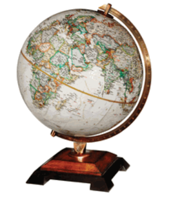
We, of course, know him for his maps that most kids in the world have used in their geography classes. They are all something like this.
 |
| Map of the world - Mercator projection |
Today, however, he is being criticised for being Eurocentric and racist because the projection distorts parts of the globe, minimising the size, for example, of Africa. If you look at the map above, Greenland looks to be about half of the size of Africa. In reality, Africa is fourteen times the size of Greenland. Similarly, Russia looks bigger than Africa, except it is actually just over half the size (17.1 million sq. km. versus 30.37 million sq. km. ).
Most readers will have seen the graphic below, which shows all the countries that could fit inside Africa.

The reality is that Mercator developed the projection for the sole purpose of helping ships navigate using only a compass. And in doing so distorted the sizes of countries - making those farthest from the equator relatively bigger and those closer to the equator relatively smaller. Doing this allowed ships to follow a constant bearing from one place to another. This is called a rhumb line.
You may be asking why he had to distort the map in the first place? The answer is that it is impossible to create a flat map of earth that maintains both size and shape.
If you were to put circles of equal size on a globe, then project them onto a flat surface using Mercator's projection, the circles would look like this.
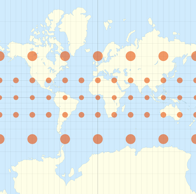

On a normal map, it looks like this.

There are actually hundreds of different map projections, each useful for a specific purpose - accurate for that purpose, and inaccurate for most others.
Even when i was young, I had a problem with globes.
If you take a close look at a globe, it is obvious that most of the land mass is in what we call the northern hemisphere.
Dirt and rocks are heavier than water. Right? So, since there is obviously more dirt and rocks in the northern hemisphere, it has to be heavier than the southern hemisphere. Right? And since heavier things sink to the bottom, what we call the northern hemisphere should be at the bottom of the globe. Right? So why is it at the top?
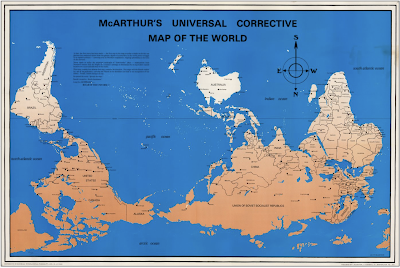
As I became more socially aware, I began to resent the fact that South Africa was at the bottom of all maps. That, together with the weight issue, made me look around. And this is what I found.

During my research for this article, I found many videos of interest.
This one is a pretty good one about map projections and their problems.
And this one, despite a few errors, is an entertaining one from West Wing.
_____________________________________________
September events:
Launch of A Deadly Covenant
Wednesday, 7. 4:30 – 5:30 pm
Totally Criminal Cocktail Hour at Valley Bookstore
The Zephyr Theatre, 601 N Main St, Stillwater, MN 55082
Find out more about the event HERE.
Friday, 9, 1:45 – 2:30 pm
BOUCHERCON Panel:
The Mystery of Multiple Points of View and Multiple Timelines (Writers use dual perspectives/multiple narrators and alternating timelines to tell their stories.)
Marty Ambrose; William Boyle; Mary R. Davidsaver; B.A. Shapiro; Julie Carrick Dalton; Stanley Trollip (Moderator)
Saturday, 10, 11:30 -12:15 pm
BOUCHERCON Panel:
Under the Sun or Below Zero (You’ve heard of “setting as a character.” Well … what about the weather? These authors’ works represent a dichotomy of climates where rising temps or bone-chilling cold are just as effective as any villain.)
Alexander McCall Smith; Stan Trollip (Michael Stanley); Catriona McPherson; Jo Nesbø ; Matthew Goldman (Moderator); Caro Ramsay
Thursday, 15, 12:30 – 1:00 pm (UK time)
Virtual event at the International Agatha Christie Festival
Agatha in Africa
Michael, Stanley and Zimbabwe author Bryony Rheam discuss Agatha Christie’s trip to South Africa and Southern Rhodesia and its connection with her mystery thriller The Man in the Brown Suit.
Monday 19, 6:00 pm
Nokomis Library event
5100 S 34th Ave, Minneapolis, MN 55417 Phone: 612-543-6800
Wednesday 21, 6:00 pm
Thomas St. Angelo Public Library of Cumberland event
1305 2nd Ave, Cumberland, WI 54829. Phone: 715-822-2767
Thursday 22, 6:30 pm
Spooner Library event
421 High St, Spooner, WI 54801 Phone. 715-635-2792
Saturday 24, 1200
The Bookstore at Fitger’s
600 East Superior Street, Duluth MN 55802
Tuesday, 27, 6:00 pm
Launch of A Deadly Covenant at Once Upon A Crime
604 W. 26th Street, Minneapolis, MN 5540 Phone: 612.870.3785 Email: onceuponacrimebooks@gmail.com
With Mary Ann Grossman
October events:
Saturday 1, 9:00 am – 3:00 pm
Meet us at the Deep Valley Book Festival
Mankato, MN
Free book festival. We’ll be there from 9am to 3pm. The event takes place at the WOW! Zone, conveniently located at 2030 Adams Street in Mankato, just off Highway 14.
Thursday 6, 7:00 pm
Barnes and Noble HarMar
2100 Snelling Ave N, Roseville, MN 55113
Saturday 8.
The Poisoned Pen Bookstore
4014 N Goldwater Blvd #101, Scottsdale, AZ 85251 Phone:(480) 947-2974 Toll Free: (888) 560-9919 Email: sales@poisonedpen.com
Stanley joins Barbara Peters on Saturday afternoon to chat about A Deadly Covenant.
Friday, 14, 10 am
Lake Country Booksellers event
4766 Washington Ave, White Bear Lake, MN 55110 Phone: 651-426-0918
Saturday, 15, 10:00 am – 5:00 pm
Twin Cities Book Festival
Minnesota State Fairgrounds, Saint Paul, Minnesota


It all comes down to some interesting mathematics - essentially spheres and planes are intrinsically different. You just can't make them "look" the same in a smooth way. After that, it comes down to what distortion you want to live with.
ReplyDeleteI didn't know all of this and loved learning about it, Thank You!
ReplyDelete