Showing posts with label maps. Show all posts

Thursday, August 11, 2022

Poor old Mercator!

 Stanley - Thursday

Poor old Gerardus Mercator.

We, of course, know him for his maps that most kids in the world have used in their geography classes. They are all something like this.

Map of the world - Mercator projection

Today, however, he is being criticised for being Eurocentric and racist because the projection distorts parts of the globe, minimising the size, for example, of Africa. If you look at the map above, Greenland looks to be about half of the size of Africa. In reality, Africa is fourteen times the size of Greenland. Similarly, Russia looks bigger than Africa, except it is actually just over half the size (17.1 million sq. km. versus  30.37 million sq. km. ).

Most readers will have seen the graphic below, which shows all the countries that could fit inside Africa.


The reality is that Mercator developed the projection for the sole purpose of helping ships navigate using only a compass. And in doing so distorted the sizes of countries - making those farthest from the equator relatively bigger and those closer to the equator relatively smaller. Doing this allowed ships to follow a constant bearing from one place to another. This is called a rhumb line.

You may be asking why he had to distort the map in the first place? The answer is that it is impossible to create a flat map of earth that maintains both size and shape.

If you were to put circles of equal size on a globe, then project them onto a flat surface using Mercator's projection, the circles would look like this.
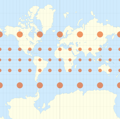

That's why Africa looks so small and Greenland so big.

While the Mercator project distorts the size of countries, it does preserve their shape (which isn't particularly useful for maritime navigation!).

About fifty years ago, some people started questioning the implications of the Mercator projection from a social perspective. Why are the European countries so big relative to African countries? Big is usually associated with power and strength, so doesn't distorting countries this way give kids an incorrect perception of the power, both military and political, of these countries?

Why are Western countries at the top of the map? Doesn't that give observers a feeling of that the top ones are superior and those at the bottom of the map inferior?

I think these are reasonable questions to ask. However, to accuse Mercator of pushing a social agenda with his map is ridiculous.

One of the people pushing this perspective was German film maker, Arno Peters. He developed a projection that generally maintained the size of countries but not their shape.

This is a map using the Peters projection of equal-sized circles. You can see clearly the differences in distortion compared to Mercator.


On a normal map, it looks like this.


In fact, Peters' projection had been developed over a hundred years earlier by the Rev. James Gall in Scotland. The projection is now known as the Gall-Peters projection.

A lot of people have taken Peter's (and others') arguments seriously, and now the Mercator projection is banned in in a number of school districts in the USA and by UNESCO. In its place is the Gall-Peters projection.

(What maps are used in countries outside the USA? Readers please chime in.)

The reality is that it is impossible to project a globe onto a plane without distortion. This is a useful short video that explains these problems.

There are actually hundreds of different map projections, each useful for a specific purpose - accurate for that purpose, and inaccurate for most others.

Even when i was young, I had a problem with globes.
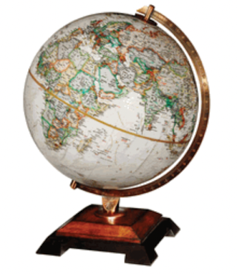

If you take a close look at a globe, it is obvious that most of the land mass is in what we call the northern hemisphere.

How is that possible? With the earth spinning, you would think it would be at the equator.

Sixty or so years ago when I first noticed this, I had no social implications in my head. My concern was more practical. 

Dirt and rocks are heavier than water. Right? So, since there is obviously more dirt and rocks in the northern hemisphere, it has to be heavier than the southern hemisphere. Right? And since heavier things sink to the bottom, what we call the northern hemisphere should be at the bottom of the globe. Right? So why is it at the top?

As I became more socially aware, I began to resent the fact that South Africa was at the bottom of all maps. That, together with the weight issue, made me look around. And this is what I found.

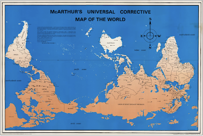


Much better - even though it has distortions. I like this perspective.

And here is a different focus. It has a very different feel to it.


You may have noticed that Google Maps, for example, still uses the Mercator projection even though country sizes are wrong. Why is this?

It boils down to the fact that when using a GPS, you are looking at a minute part of a country - so small, in fact, that the distortion is irrelevant. And since the country shape is preserved, the map on the GPS is so close to reality to be not worth worrying about.

So, to get back where I started, I feel sympathy for Gerardus Mercator, unfairly blamed for all sorts of social crimes. However, his maps have caused reasonable questions to be raised. They deserve a debate.

During my research for this article, I found many videos of interest.

This one is a pretty good one about map projections and their problems.

And this one, despite a few errors, is an entertaining one from West Wing.

_____________________________________________

September events:


Launch of A Deadly Covenant


Wednesday, 7. 4:30 – 5:30 pm 

Totally Criminal Cocktail Hour at Valley Bookstore

The Zephyr Theatre, 601 N Main St, StillwaterMN 55082

Find out more about the event HERE.


Friday, 9, 1:45 – 2:30 pm 

BOUCHERCON Panel:

The Mystery of Multiple Points of View and Multiple Timelines (Writers use dual perspectives/multiple narrators and alternating timelines to tell their stories.)

Marty Ambrose; William Boyle; Mary R. Davidsaver; B.A. Shapiro; Julie Carrick Dalton; Stanley Trollip (Moderator)

Saturday, 10, 11:30 -12:15 pm 

BOUCHERCON Panel:

Under the Sun or Below Zero (You’ve heard of “setting as a character.” Well … what about the weather?  These authors’ works represent a dichotomy of climates where rising temps or bone-chilling cold are just as effective as any villain.)

Alexander McCall Smith; Stan Trollip (Michael Stanley); Catriona McPherson; Jo Nesbø ; Matthew Goldman (Moderator); Caro Ramsay

Thursday, 15, 12:30 – 1:00 pm (UK time) 

Virtual event at the International Agatha Christie Festival

Agatha in Africa

Michael, Stanley and Zimbabwe author Bryony Rheam discuss Agatha Christie’s trip to South Africa and Southern Rhodesia and its connection with her mystery thriller The Man in the Brown Suit.


Monday 19, 6:00 pm 

Nokomis Library event

5100 S 34th Ave, Minneapolis, MN 55417 Phone: 612-543-6800


Wednesday 21, 6:00 pm 

Thomas St. Angelo Public Library of Cumberland event

1305 2nd Ave, Cumberland, WI 54829. Phone: 715-822-2767


Thursday 22, 6:30 pm 

Spooner Library event

421 High St, Spooner, WI 54801 Phone. 715-635-2792


Saturday 24, 1200

The Bookstore at Fitger’s

600 East Superior Street, Duluth MN 55802


Tuesday, 27, 6:00 pm 

Launch of A Deadly Covenant at Once Upon A Crime

604 W. 26th Street, MinneapolisMN 5540 Phone: 612.870.3785 Email: onceuponacrimebooks@gmail.com

With Mary Ann Grossman

October events:


Saturday 1, 9:00 am – 3:00 pm

Meet us at the Deep Valley Book Festival

Mankato, MN

Free book festival. We’ll be there from 9am to 3pm. The event takes place at the WOW! Zone, conveniently located at 2030 Adams Street in Mankato, just off Highway 14.


Thursday 6, 7:00 pm

Barnes and Noble HarMar

2100 Snelling Ave N, Roseville, MN 55113


Saturday 8. 

The Poisoned Pen Bookstore

4014 N Goldwater Blvd #101, Scottsdale, AZ 85251 Phone:(480) 947-2974 Toll Free: (888) 560-9919 Email: sales@poisonedpen.com

Stanley joins Barbara Peters on Saturday afternoon to chat about A Deadly Covenant.


Friday, 14, 10 am 

Lake Country Booksellers event

4766 Washington Ave, White Bear Lake, MN 55110 Phone: 651-426-0918


Saturday, 15, 10:00 am – 5:00 pm 

Twin Cities Book Festival

Minnesota State Fairgrounds, Saint Paul, Minnesota


Thursday, June 24, 2021

Attraction

Stanley - Thursday

I've always been fascinated by attraction. What makes one person attractive to some people, but not others. As I walk through a museum or gallery, why do some paintings or other pieces of art jump out at me, and not others. Why can I listen to some pieces of music time after time, but others I won't listen to twice? What is happening inside me to elicit such responses?

Unfortunately, I have no idea. It just happens.

Certainly, I can like broad categories of art, for example the Impressionists, but dislike or am not attracted to many paintings subsumed under that name. I love African carvings, in general, but many items don't make my heart beat faster. 

As I sit in my living room writing this blog, I look around and know I like all the masks, carvings, sculptures, and various maps and woodcuts. Surprisingly, nothing has fallen out of my favour. I still like them after many years.

However, there are a handful that I love, that stand out in my mind as being something special. I keep wondering why - why them, and not others on the same shelf?

Again, I have no idea.

Over the years, I have come to realise that there are two different types of attraction for me - one of the heart and one of the mind. Needless to say, the ones that grab my heart are the ones I gravitate towards.

Let me give you a few examples.

On one wall I have three maps of Africa. The first was originally drawn in the 1570's by a cartographer named Ortelius. I'm attracted to it through my brain. It is astonishingly accurate given that the notion of determining longitude by using a clock was only proposed in 1530 by Gemma Frisius, and it was in the mid-1700s that John Harrison produced a marine chronometer that met the stringent requirements of accuracy required for accurate navigation and cartography. How did Ortelius manage something so good without accurate instruments - not to mention the problems of circumnavigating - almost - the whole continent of Africa? My mind boggles.

Drawn in the 1570s

This map was drawn in about 1700.

Drawn about 1700

And this one in 1800.

Drawnn about 1800

Opposite the maps are a few woodcuts from a collection of forty-two by the South African artist, Cecil Skotness, depicting the life and death of the famous Zulu chief, Shaka. Like the maps, they are two-dimensional. Unlike the maps, this one grabs my heart.

One of the Skotnes woodcuts

On a shelf below the Skotnes are two remarkable pieces, both from what is now Nigeria. The first is a carved ivory piece, probably used by a prominent person for holding valuables, such as jewellery. As you can see, the carving is exquisite. Also, a slight twist opens it or shuts it. It is a masterpiece of carving.  However, my heart doesn't race when I see it. It's mainly my mind that is attracted.

Ivory valuables holder from Nigeria, circa 1900

The holder opened

The piece next to it is all heart for me. I have shown it here in the blog before. It is a 500-700 year-old terracotta sculpture from Ife. I fell in love with her the moment I set eyes on her. Of course, my mind also admires her, but that's nothing compared to what happens to my heart.

Terracotta head from Ife

I have a small carving of a lion that I bought fifty years ago from one of the nastiest people I've ever met - an ex-mercenary in a number of African conflicts. The last I heard of him, he had burnt down his warehouse to claim the insurance. Since most of his art works were African wood pieces, I suspect few remained in the building when it was torched. For inexplicable reasons, my heart goes pit-a-pat when I pick it up.

My kitty cat

I have a very similar reaction when I look at a sandstone polar bear, carved by an Innuit artist, that I also bought also fifty years ago. I walked into a gallery in Toronto while hitchhiking around the States, and found it irresistible.  It is extremely heavy, and there were moments when I continued my journey that I thought my backpack was going to collapse.

Front of my bear


Rear of my bear

Finally, I have a general affinity to Mkonde spirit sculptures. They are relatively modern and come from northern Mozambique and southern Tanzania. Their tortured, grotesque figures appeal to me no end - in the heart.


I have come to realise that when I am intrigued by a piece, it is my brain that is attracted. When something takes my breath away, it is my heart. For both brain and heart, however, I've no idea what makes some pieces so attractive and some not. 


Wednesday, July 31, 2019

A Road Map of Bombay

Sujata Massey


Lately, my work in progress has been dragging its feet. Maybe it's because I'm writing from my home in Baltimore, while I long to revitalize myself with a walk through Fort, the historic Bombay neighborhood I write about in the Perveen Mistry novels. Even though I've been there in person, I feel like I need to be led along the streets again.

If I could step into an old map, it would fix everything, wouldn't it?

Maps inside a book are like sugar in dessert. You don't need it, but it's so much nicer when it's there.


Philip Schwartzberg's map created for Widows 


My relationship with maps did not start out well. I used to be terrified of when my parents were driving, and we got lost. The driving parent would call out for someone (the spouse or eldest child in the car--yours truly) to study a large, cumbersome road map and discern the correct way back. It seemed I  could never read the map fast enough nor could I orient myself in a direction other than the printed paper. Because of the way my brain processes direction, I was not a natural fit with maps--though I need them, because I have a terrible instinct for misdirection.

I began feeling less overwhelmed by maps when I lived in Japan. This was the era when I was a foreigner in Japan doing groundwork for a first novel. I wanted to write a mystery that felt real; and for me, that meant naming actual streets and train stations. The little line maps on the back of every shop or restaurant's business card were my salvation in cities like Tokyo and Yokohama where many streets didn't have names, just numbered buildings.

After publication of my first book, The Salaryman's Wife, I learned how attentive readers are to details of place. If I located a known building on the wrong corner, I would hear about it. But just as quickly as people catch errors, they also delight in hearing the names for almost-forgotten places.

In India, many city and street names have changed due to political progress--and here I am, sounding like an old person, talking about "Bombay" instead of Mumbai and "Bruce Street" instead of Homi Modi Street. I search out the oldest-looking places and commit them to my camera, and my heart.


On the way to Crawford Market


Apollo Bunder, with the Taj Hotel


After independence in 1947, Indians refused to continue speaking of streets named for men who were the enforcers of its colonial past. Many city and street names on maps officially changed from English government officials to Indian heroes, although verbally, the English names are often still used in spoken directions by locals. Ironically, there is at least one area renamed after a British person: Horniman Circle. Benjamin Horniman was a progressive British journalist who was thrown out of the country in the early 1900s for writing supportively of Mahatma Gandhi. The handsome driving circle in South Mumbai framed by offices and shops had previously been named in honor of the 13th Lord Elphinstone, one of Bombay's governors. If I hadn't learned who Mr. Horniman was, I might have mistakenly misnamed the circle in my novel. Interestingly, there still is an Elphinstone College in Bombay (named after the second Lord Elphinstone) as well as Wilson College, named for the Scottish Presbyterian missionary educator who founded it.

 Horniman Circle (once Elphinstone Circle)


For quite a few years, I have been gathering such arcane details from old guidebooks and maps. Some of my key sources are huge, vintage reference books like the Imperial Gazetteers of British India, and  old city guidebooks, especially if they have maps. The best place in the United States I know to find such wonders is the Ames Library within the University of Minnesota.


Rare antique travel guides to Bombay at Ames Library


The newly translated vintage guide


Karl S. Baedeker was the famous publisher of 19th and early 20th century travel guides that originated in Germany, a country with people still passionate about travel. The Baedeker guides were  meant to help Westerners see marvelous places beyond their imaginations, all the while in comfort and security. Baedeker guides were often translated into English. However, the 1914 Baedeker's only guide to India was published in 1914, and due to hostilities between Germany and Britain, never found an English language publisher. Not until 1985 was the guide translated into English by Michael Wild.  I was grateful to be able to buy the modern translation and picked up from it some interesting details about the city from an early 20th century German viewpoint.

Because old maps are very helpful, I was tempted when I discovered a 1967 Bombay folding map being auctioned on eBay by a seller in England with a starting price of 49 pounds. Once airmail delivery was included, the map would run me about $77 US dollars.


I've bought moisturizers that cost more, but I hesitated. My worry was this mysterious map on eBay would be focused exclusively on tourism venues. I knew it also would have plenty of Indian street names, so I would continue to need to cross-reference street names.


The seller had posted some photos of the map booklet that looked promising, so I pressed the button to bid. It was the last day of the auction, and it turned out I was the only person on earth interested in a Tej Brothers 1967 Bombay Street Map.


Two weeks later, a neat little package in a sturdy, waterproof envelope arrived from England. The map booklet had traveled safely between two pieces of cardboard inside the package. It was just the right size to put inside a handbag, yet it was utterly fresh, as if it had never been opened up and read. To say this map is in perfect condition is an understatement. Some of the booklet pages unfold into very large, easy to read maps which are rich in color and landmarks.


The booklet also has listings of popular name of restaurants and hotels, movie houses and shops. I can't wait to show it to my stepfather, who was a young man-about-town during the map's prime.

In the week that I've been studying it, the map's provenance has intrigued me. Because there is absolutely no smell of mold or deterioration from moisture, I believe the map probably left India many years ago and was kept in a cool, dry location. I wonder: was the map's first owner someone who meant to use it while exploring Bombay, but instead relied on the directions of a human companion? Or did the planned trip to Bombay get cancelled? Could it be the map never had a real owner, but just resided for decades in a travel agent's file cabinet?

I've come to realize that a map can offer much more than geographic placement or inspiration for story; it can be a mystery unto itself.